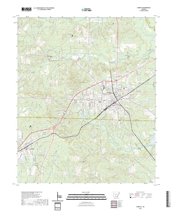
2024 Map of Fordyce
USGS Topo · Published 2024About this map
Fordyce serves as the central hub of this modern Arkansas landscape, anchoring a network of roads that bridge the timberlands between Dallas and Calhoun counties. The town's grid is anchored by the County Courthouse, while residential expansion reaches outward toward smaller communities like Beech Grove and Thornton. To the north, the curiously named settlement of Bucksnort sits near Jacobs Lake, marking an area characterized by a complex hydrographic system where Hurricane Creek and Cooks Creek wind through the terrain. The map records a series of traditional burial grounds including Oakland Cem and Greenville Cem, alongside recreational and natural water bodies such as Lake Lansdale and Lake Cathay. This contemporary survey illustrates the persistent importance of local connectors and rural roads in maintaining the social fabric of south-central Arkansas.
Find a feature on this map
121 named features on this map. Tap any name to fly to it.
Don’t see what you’re looking for? This feature index may not catch every label — zoom into the map to look around manually.
Map Details
Editions of this 2024 Fordyce Map
This is the sole edition of this map. No revisions or reprints were ever made.
Other maps of this area

1903 · Camden
USGS Topo · 1:125,000

1953 · El Dorado
USGS Topo · 1:250,000

1957 · El Dorado
USGS Topo · 1:250,000

1958 · El Dorado
USGS Topo · 1:250,000

1960 · El Dorado
USGS Topo · 1:250,000

1966 · Kingsland
USGS Topo · 1:24,000

1966 · Fordyce
USGS Topo · 1:24,000
1969 · Ivan
USGS Topo · 1:24,000
1970 · Fordyce NE
USGS Topo · 1:24,000

1973 · Bearden
USGS Topo · 1:24,000