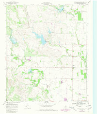
1968 Map of Foreman Chapel
USGS Topo · Published 1981About this map
Foreman Chapel stands as a focal point in this West Texas landscape, where the drainages of Cottonwood Creek and Duck Creek carve through the Dickens County terrain. Originally mapped in the late 1960s with updates through the early 1980s, the map documents a rural economy defined by cattle ranching and resource extraction, evidenced by scattered Gravel Pits and various water wells. The inclusion of the Espuela Cem and small settlement points like Dockum and Hackberry provides critical spatial data for genealogists tracing family roots in this part of the state. A notable 1979 revision identifies a Landing Strip and small reservoirs, illustrating the gradual infrastructure changes in this region. The relationship between the topographic relief of Dockum Draw and the established road network reveals how the physical geography shaped the placement of local landmarks and transit routes.
Find a feature on this map
13 named features on this map. Tap any name to fly to it.
Don’t see what you’re looking for? This feature index may not catch every label — zoom into the map to look around manually.
Map Details
Editions of this 1968 Foreman Chapel Map
2 editions found
Other maps of this area

1954 · Lubbock
USGS Topo · 1:250,000

1961 · Bunker Hill
USGS Topo · 1:24,000

1962 · Smith Tank
USGS Topo · 1:24,000

1966 · McAdoo
USGS Topo · 1:24,000

1967 · Dickens North
USGS Topo · 1:24,000

1967 · Dickens South
USGS Topo · 1:24,000

1967 · Spur
USGS Topo · 1:24,000

1967 · Haystack Mountain
USGS Topo · 1:24,000

1967 · Spur NW
USGS Topo · 1:24,000

1968 · Foreman Chapel
USGS Topo · 1:24,000