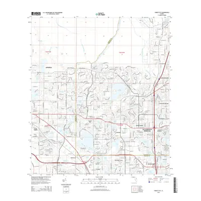
2015 Map of Forest City
USGS Topo · Published 2015About this map
Altamonte Springs and the surrounding central Florida suburbs occupy a landscape defined by an intricate network of freshwater lakes and spring-fed runs. The drainage of Rock Springs Run and the Wekiva River dominates the northern sector, leading to the well-known Wekiva Springs area. This 2015 survey illustrates the dense residential expansion between Apopka and Longwood, where modern developments are woven around historic water bodies like Lake Brantley and Lake Lotus. The map records the heavy infrastructure of the era, including the CSX Transportation rail line and major arteries like the Orange Blossom Trl. Smaller established communities such as Forest City, Piedmont, and Lockhart appear as integral parts of the metropolitan fabric, while landmarks like Sanlando Springs and Orienta Gardens highlight the region's long-standing connection to its natural hydrology.
Find a feature on this map
66 named features on this map. Tap any name to fly to it.
Don’t see what you’re looking for? This feature index may not catch every label — zoom into the map to look around manually.
Map Details
Editions of this 2015 Forest City Map
This is the sole edition of this map. No revisions or reprints were ever made.
Other maps of this area

1955 · Orlando
USGS Topo · 1:250,000

1956 · Winter Garden
USGS Topo · 1:24,000

1956 · Orlando West
USGS Topo · 1:24,000

1956 · Orlando East
USGS Topo · 1:24,000

1957 · Orlando
USGS Topo · 1:250,000

1958 · Orlando
USGS Topo · 1:250,000

1959 · Forest City
USGS Topo · 1:24,000

1960 · Sorrento
USGS Topo · 1:24,000

1960 · Apopka
USGS Topo · 1:24,000

1962 · Orlando
USGS Topo · 1:250,000