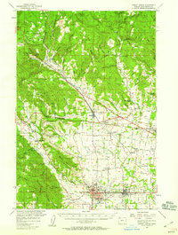
1956 Map of Forest Grove
USGS Topo · Published 1959About this map
Forest Grove and Cornelius anchor the southern plains of Washington County in the mid-1950s, a landscape defined by the intersection of the Tualatin River and a dense network of early rail lines. The presence of Pacific University in the heart of Forest Grove highlights the area's long-standing cultural importance, while rural life is centered around community nodes like Verboort, Banks, and the small settlement of Kansas City. The transit infrastructure of the era is remarkably preserved on this sheet, showing the routes of the Southern Pacific, the S P & S, and the Oregon Electric Line alongside major arterial roads like the Wolf Creek Highway. To the north and west, the terrain rises into the foothills of the Coast Range, where landmarks like Green Mtn and Bald Mtn overlook timbered canyons and headwater creeks such as Hares Creek and Lousignont Creek. Local history is deeply embedded in the map's fine details, from the Visitation Ch in Verboort to numerous rural schools and cemeteries like Union Point Cemetery.
Find a feature on this map
88 named features on this map. Tap any name to fly to it.
Don’t see what you’re looking for? This feature index may not catch every label — zoom into the map to look around manually.
Map Details
Editions of this 1956 Forest Grove Map
3 editions found
Other maps of this area

1915 · Hillsboro
USGS Topo · 1:62,500

1916 · Tualatin
USGS Topo · 1:62,500

1918 · Hillsboro
USGS Topo · 1:62,500

1922 · St. Helens
USGS Topo · 1:62,500

1939 · Tualatin
USGS Topo · 1:62,500

1940 · Tualatin
USGS Topo · 1:62,500

1940 · Hillsboro
USGS Topo · 1:62,500

1940 · Vernonia
USGS Topo · 1:62,500

1941 · Keasey
USGS Topo · 1:62,500

1941 · St Helens
USGS Topo · 1:62,500