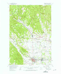
1956 Map of Forest Grove
USGS Topo · Published 1964About this map
The Pacific University campus serves as the cultural anchor for Forest Grove, situated where the agricultural Tualatin Valley meets the rising foothills of the Coast Range. This mid-century survey details the critical intersection of the Southern Pacific and S P & S railroads, which facilitated the movement of timber and crops through junctions like Banks and Cornelius. The landscape transitions from the dense timberlands around Green Mtn and Wildcat Mtn to the meticulously plotted farmlands of the valley floor, where many rural schoolhouses like Meacham School and Leisy School remained as community landmarks.
Find a feature on this map
166 named features on this map. Tap any name to fly to it.
Don’t see what you’re looking for? This feature index may not catch every label — zoom into the map to look around manually.
Map Details
Editions of this 1956 Forest Grove Map
3 editions found
Other maps of this area

1915 · Hillsboro
USGS Topo · 1:62,500

1916 · Tualatin
USGS Topo · 1:62,500

1918 · Hillsboro
USGS Topo · 1:62,500

1922 · St. Helens
USGS Topo · 1:62,500

1939 · Tualatin
USGS Topo · 1:62,500

1940 · Tualatin
USGS Topo · 1:62,500

1940 · Hillsboro
USGS Topo · 1:62,500

1940 · Vernonia
USGS Topo · 1:62,500

1941 · Keasey
USGS Topo · 1:62,500

1941 · St Helens
USGS Topo · 1:62,500