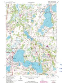
1974 Map of Forest Lake
USGS Topo · Published 1993About this map
Forest Lake serves as the central hub of this lake-strewn landscape where the Chisago and Washington County line divides the region. The map captures a moment of residential development and recreation around significant water bodies such as Green Lake and Chisago Lake. Large tracts of protected land are visible, most notably the Carlos Avery State Wildlife Management Area in the northwest, which preserves the marshy character of the terrain. The infrastructure of the era is marked by the Burlington Northern railroad and remnants of travel history like the Old Railroad Grade. Community life is anchored by institutions like the Forest Lake High School and several local burial grounds, including the Scandinavian Cemetery and St Pauls Cemetery. The geography is defined by prominent peninsulas like Simmons Point and Lindberg Point, reflecting the deep connection between the local settlements and the surrounding shoreline.
Find a feature on this map
60 named features on this map. Tap any name to fly to it.
Don’t see what you’re looking for? This feature index may not catch every label — zoom into the map to look around manually.
Map Details
Editions of this 1974 Forest Lake Map
2 editions found
Other maps of this area

1902 · White Bear
USGS Topo · 1:62,500

1948 · Stillwater
USGS Topo · 1:62,500

1949 · Stillwater
USGS Topo · 1:62,500

1952 · Centerville
USGS Topo · 1:24,000

1953 · Stillwater
USGS Topo · 1:250,000

1954 · Hugo
USGS Topo · 1:24,000

1955 · Marine
USGS Topo · 1:24,000

1955 · Forest Lake
USGS Topo · 1:62,500

1955 · Isanti
USGS Topo · 1:62,500
1955 · New Brighton
USGS Topo · 1:62,500