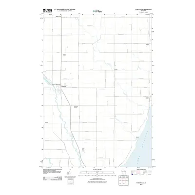
2010 Map of Forestville
USGS Topo · Published 2010About this map
The Ahnapee River winds through the village of Forestville, where the Forestville 1885C70 Dam regulates the waters of the Forestville Flowage. This 2010 topographic record of southern Door County shows a landscape defined by traditional agricultural blocks and small crossroads settlements such as Maplewood, Carnot, and Kodan. To the east, the terrain meets the shoreline of Lake Michigan near the Woodside Cemetery, while the small Foscoro Airport sits further inland. Genealogists can identify key local burial sites including Saint Mary Cemetery and Brockhausen Cemetery. The map captures the complex drainage of the peninsula, illustrated by the convergence of Stony Creek, Bear Creek, and Silver Creek as they flow toward the lake or the river valley.
Find a feature on this map
65 named features on this map. Tap any name to fly to it.
Don’t see what you’re looking for? This feature index may not catch every label — zoom into the map to look around manually.
Map Details
Editions of this 2010 Forestville Map
This is the sole edition of this map. No revisions or reprints were ever made.
Other maps of this area

1952 · Casco
USGS Topo · 1:62,500

1954 · Manitowoc
USGS Topo · 1:250,000

1958 · Manitowoc
USGS Topo · 1:250,000

1960 · Sturgeon Bay
USGS Topo · 1:62,500

1960 · Algoma
USGS Topo · 1:62,500

1961 · Little Sturgeon
USGS Topo · 1:62,500

1978 · Casco
USGS Topo · 1:24,000

1978 · Brussels
USGS Topo · 1:24,000

1981 · Sturgeon Bay West
USGS Topo · 1:24,000
1981 · Sturgeon Bay East
USGS Topo · 1:24,000