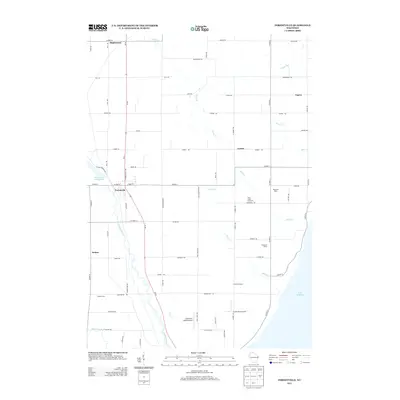
2013 Map of Forestville
USGS Topo · Published 2013About this map
The Ahnapee River winds through the heart of this Door County landscape, feeding into the Forestville Flowage 40 near the village of Forestville. This survey illustrates a resilient agricultural and maritime corridor, where the land transitions from the river valley eastward to the shoreline of Lake Michigan. Small hamlets such as Maplewood, Vignes, and Kodan serve as anchors for the surrounding farmsteads. The agricultural character is deeply rooted, evidenced by named operations like Harmann Farms, Peninsula Dairy, and Kirchman Farms. Local commerce and transportation are further represented by the Jorgensen - Stoller Airport and the Stony Creek Vineyards. Numerous creeks, including Stony Cr, Bear Cr, and Silver Cr, create a dense drainage network that has historically dictated road placement and property boundaries throughout the region.
Find a feature on this map
72 named features on this map. Tap any name to fly to it.
Don’t see what you’re looking for? This feature index may not catch every label — zoom into the map to look around manually.
Map Details
Editions of this 2013 Forestville Map
This is the sole edition of this map. No revisions or reprints were ever made.
Other maps of this area

1952 · Casco
USGS Topo · 1:62,500

1954 · Manitowoc
USGS Topo · 1:250,000

1958 · Manitowoc
USGS Topo · 1:250,000

1960 · Sturgeon Bay
USGS Topo · 1:62,500

1960 · Algoma
USGS Topo · 1:62,500

1961 · Little Sturgeon
USGS Topo · 1:62,500

1978 · Casco
USGS Topo · 1:24,000

1978 · Brussels
USGS Topo · 1:24,000

1981 · Sturgeon Bay West
USGS Topo · 1:24,000
1981 · Sturgeon Bay East
USGS Topo · 1:24,000