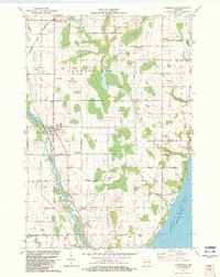
1982 Map of Forestville
USGS Topo · Published 1983About this map
The Ahnapee River winds through the heart of the Door and Kewaunee County line, anchored by the settlement of Forestville. This 1982 map shows a landscape defined by its rural intersections and watercourses, from the Forestville Flowage to the shoreline of Lake Michigan in the east. The area is dense with community landmarks that provide significant value for genealogists, including St Marys Ch, Forest Chapel, and several local burial grounds like Brockhausen Cem and Woodside Cem. Small crossroads like Maplewood, Carnot, and Vignes are linked by a grid of named routes including Maplewood Road and Carnot Road. The presence of numerous Gravel Pits and a Quarry near the State Trail suggests a steady local industry of resource extraction, while the scattered wooded tracts and creek beds of Stony Creek and Silver Creek reveal the persistence of the region's natural drainage patterns amidst its agricultural development.
Find a feature on this map
49 named features on this map. Tap any name to fly to it.
Don’t see what you’re looking for? This feature index may not catch every label — zoom into the map to look around manually.
Map Details
Editions of this 1982 Forestville Map
This is the sole edition of this map. No revisions or reprints were ever made.
Other maps of this area

1952 · Casco
USGS Topo · 1:62,500

1954 · Manitowoc
USGS Topo · 1:250,000

1958 · Manitowoc
USGS Topo · 1:250,000

1960 · Sturgeon Bay
USGS Topo · 1:62,500

1960 · Algoma
USGS Topo · 1:62,500

1961 · Little Sturgeon
USGS Topo · 1:62,500

1978 · Casco
USGS Topo · 1:24,000

1978 · Brussels
USGS Topo · 1:24,000

1981 · Sturgeon Bay West
USGS Topo · 1:24,000
1981 · Sturgeon Bay East
USGS Topo · 1:24,000