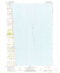
1963 Map of Forestville
USGS Topo · Published 1978About this map
Lake Huron defines the eastern edge of this Michigan thumb coastline, where early 1960s settlements like Forestville and White Rock sit perched above the water. The landscape is deeply carved by a series of parallel watercourses flowing east into the lake, including White River, Mill Creek, and Slatestone Creek. This coastal strip shows a transition between shoreline recreation at Stephens Park and the agricultural interior, which is partitioned by family-named roads such as Munford Road and Potts Road.
Find a feature on this map
36 named features on this map. Tap any name to fly to it.
Don’t see what you’re looking for? This feature index may not catch every label — zoom into the map to look around manually.
Map Details
Editions of this 1963 Forestville Map
2 editions found
Other maps of this area

1954 · Flint
USGS Topo · 1:250,000

1958 · Flint
USGS Topo · 1:250,000

1963 · Forestville
USGS Topo · 1:24,000

1963 · Ruth
USGS Topo · 1:24,000

1963 · Deckerville
USGS Topo · 1:24,000

1963 · Richmondville
USGS Topo · 1:24,000

1970 · Harbor Beach
USGS Topo · 1:24,000

1984 · Harbor Beach
USGS Topo · 1:100,000
2011 · Deckerville
USGS Topo · 1:24,000
2011 · Forestville
USGS Topo · 1:24,000