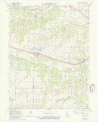
1972 Map of Foristell
USGS Topo · Published 1982About this map
The Norfolk and Western railway corridor serves as a central artery for this section of eastern Missouri, where the boundaries of Warren, Lincoln, and St. Charles Counties converge. The settlement of Foristell and the community of Pauldingville are established alongside a complex drainage network that includes Peruque Creek and Indian Camp Creek. Local history is preserved in landmarks such as Smith Chapel, Shiloh Ch, and several family burial grounds like Metcalf Cem and Pauldingville Cem.
Find a feature on this map
59 named features on this map. Tap any name to fly to it.
Don’t see what you’re looking for? This feature index may not catch every label — zoom into the map to look around manually.
Map Details
Editions of this 1972 Foristell Map
3 editions found
Other maps of this area

1890 · Hermann
USGS Topo · 1:125,000

1903 · O'Fallon
USGS Topo · 1:125,000

1941 · Troy
USGS Topo · 1:62,500

1943 · Warrenton
USGS Topo · 1:62,500

1945 · Troy
USGS Topo · 1:62,500

1945 · Warrenton
USGS Topo · 1:62,500

1948 · Washington
USGS Topo · 1:62,500

1948 · Augusta
USGS Topo · 1:62,500

1949 · Saint Louis
USGS Topo · 1:250,000
1949 · Washington
USGS Topo · 1:62,500