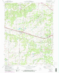
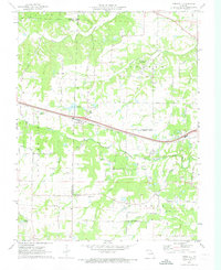
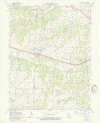
1972 Map of Foristell
USGS Topo · Published 1982About this map
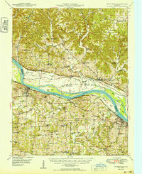
The Norfolk and Western railroad corridor anchors this survey of eastern Missouri, passing directly through the community of Foristell. The landscape is defined by the headwaters of Peruque Creek and Dardenne Creek, which cut through the townships of Cuivre and Hickory Grove. Local industry is evidenced by several scattered Claypit operations, while the Mid America Raceway occupies a large tract north of the rail line. Genealogists will find significant value in the family and community burial grounds, including Metcalf Cem, Oak Grove Cem, and the Pauldingville Cem near the settlement of Pauldingville. Numerous named rural routes like Stringtown Road and Meinershagen Road provide a detailed look at the local transport network connecting historic churches such as Smith Chapel and Shiloh Ch during the early 1970s.
Find a feature on this map
40 named features on this map. Tap any name to fly to it.
Don’t see what you’re looking for? This feature index may not catch every label — zoom into the map to look around manually.
Map Details
Editions of this 1972 Foristell Map
3 editions found
Other maps of this area

1890 · Hermann
USGS Topo · 1:125,000

1903 · O'Fallon
USGS Topo · 1:125,000

1941 · Troy
USGS Topo · 1:62,500

1943 · Warrenton
USGS Topo · 1:62,500

1945 · Troy
USGS Topo · 1:62,500

1945 · Warrenton
USGS Topo · 1:62,500
1948 · Washington
USGS Topo · 1:62,500

1948 · Augusta
USGS Topo · 1:62,500

1949 · Saint Louis
USGS Topo · 1:250,000
1949 · Washington
USGS Topo · 1:62,500