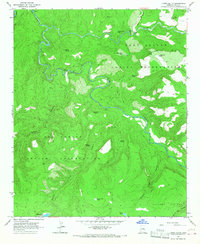
1966 Map of Forks Butte
USGS Topo · Published 1967About this map
The confluence of high-desert waterways and tribal boundaries defines this mid-1960s landscape, where the Black River and White River meet to form the headwaters of the Salt River. This confluence occurs at the intersection of the Fort Apache Indian Reservation and the San Carlos Indian Reservation, a region characterized by dramatic elevation shifts from the Sevenmile Rim down into deep river canyons.
Find a feature on this map
33 named features on this map. Tap any name to fly to it.
Don’t see what you’re looking for? This feature index may not catch every label — zoom into the map to look around manually.
Map Details
Editions of this 1966 Forks Butte Map
This is the sole edition of this map. No revisions or reprints were ever made.
Other maps of this area

1954 · Mesa
USGS Topo · 1:250,000

1957 · Mesa
USGS Topo · 1:250,000

1958 · Mesa
USGS Topo · 1:250,000

1960 · Mesa
USGS Topo · 1:250,000

1964 · Mesa
USGS Topo · 1:250,000

1966 · Georges Butte
USGS Topo · 1:24,000

1966 · Popcorn Canyon
USGS Topo · 1:24,000
1966 · Cone Butte
USGS Topo · 1:24,000
1966 · Sontag Creek
USGS Topo · 1:24,000
1966 · Velasquez Butte
USGS Topo · 1:24,000