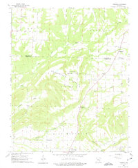
1962 Map of Formosa
USGS Topo · Published 1975About this map
Woolverton Mountain and Lick Mountain dominate the topography of this central Arkansas landscape, where the border of Van Buren and Conway Counties cuts through a network of creeks and small farming communities. Small settlements like Formosa, Claude, and Center Ridge are connected by winding roads that follow the ridges, avoiding the deep draws carved by Hogans Creek and Remove Point Creek. This survey reflects a deeply established rural social fabric, anchored by numerous landmark churches such as Union Hill Ch and Mountain View Ch. Genealogy researchers will find significant detail in the mapping of local burial grounds, including the Woolverton Mountain Cem and Halbrooks Cem, which sit alongside family-named terrain features that define the regional geography during the early 1960s.
Find a feature on this map
29 named features on this map. Tap any name to fly to it.
Don’t see what you’re looking for? This feature index may not catch every label — zoom into the map to look around manually.
Map Details
Editions of this 1962 Formosa Map
2 editions found
Other maps of this area

1892 · Marshall
USGS Topo · 1:125,000

1892 · Mountain View
USGS Topo · 1:125,000

1892 · Morrillton
USGS Topo · 1:125,000

1894 · Mountain View
USGS Topo · 1:125,000

1894 · Morrillton
USGS Topo · 1:125,000

1894 · Marshall
USGS Topo · 1:125,000

1901 · Marshall
USGS Topo · 1:125,000

1956 · Russellville
USGS Topo · 1:250,000

1961 · Bee Branch
USGS Topo · 1:62,500

1961 · Bee Branch
USGS Topo · 1:24,000