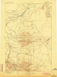
1897 Map of Fort Benton
USGS Topo · Published 1903About this map
Fort Benton stands as the primary hub of this North Central Montana landscape, situated at the confluence of the Missouri River, Teton River, and Marias River. During the late nineteenth century, this region served as a critical junction for transport, where the Great Northern Ry. followed the river valleys while the Montana Central River extended southward toward the high country. The map captures the transition from the river plains to the formidable Highwood Mountains and the northern reaches of the Little Belt Mountains.
Find a feature on this map
104 named features on this map. Tap any name to fly to it.
Don’t see what you’re looking for? This feature index may not catch every label — zoom into the map to look around manually.
Map Details
Editions of this 1897 Fort Benton Map
4 editions found
Other maps of this area

1886 · Great Falls
USGS Topo · 1:250,000

1886 · Fort Logan
USGS Topo · 1:250,000

1886 · Little Belt Mts.
USGS Topo · 1:250,000

1889 · Big Snowy Mountain
USGS Topo · 1:250,000

1890 · Fort Benton
USGS Topo · 1:250,000

1892 · Fort Benton
USGS Topo · 1:250,000

1893 · Big Snowy Mountain
USGS Topo · 1:250,000

1894 · Little Belt Mts.
USGS Topo · 1:250,000

1897 · Fort Benton
USGS Topo · 1:250,000

1897 · Little Belt Mts.
USGS Topo · 1:250,000