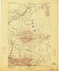
1897 Map of Fort Benton
USGS Topo · Published 1914About this map
Fort Benton stands as a pivotal river hub at the confluence of the Maria's River, Teton River, and Missouri River. This late-nineteenth-century survey captures the region during a transition from river-based commerce to rail dominance, marked by the presence of the Great Northern Ry. passing through Tunis. The terrain is dominated by two massive volcanic uplifts: the Highwood Mountains, with peaks like Highwood Peak and Arrow Peak, and the northern edge of the Little Belt Mountains.
Find a feature on this map
100 named features on this map. Tap any name to fly to it.
Don’t see what you’re looking for? This feature index may not catch every label — zoom into the map to look around manually.
Map Details
Editions of this 1897 Fort Benton Map
4 editions found
Other maps of this area

1886 · Great Falls
USGS Topo · 1:250,000

1886 · Fort Logan
USGS Topo · 1:250,000

1886 · Little Belt Mts.
USGS Topo · 1:250,000

1889 · Big Snowy Mountain
USGS Topo · 1:250,000

1890 · Fort Benton
USGS Topo · 1:250,000

1892 · Fort Benton
USGS Topo · 1:250,000

1893 · Big Snowy Mountain
USGS Topo · 1:250,000

1894 · Little Belt Mts.
USGS Topo · 1:250,000

1897 · Fort Benton
USGS Topo · 1:250,000

1897 · Little Belt Mts.
USGS Topo · 1:250,000