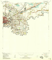
1955 Map of Fort Brown
USGS Topo · Published 1958About this map
The Rio Grande snakes through the southern tip of Texas, defining the international boundary between the United States and Mexico. This mid-century landscape is dominated by the sprawling city of Brownsville, where the historical Fort Brown reservation stands near the river’s edge. The surrounding terrain is a network of irrigation ditches, flumes, and old river oxbows known as resacas, including Resaca de la Palma and Resaca del Rancho Viejo. These water features supported agricultural interests like the Brulay Plantation and English Farms. Civil War history is preserved at the Palmito Hill Battlefield to the east, marked by a Historical Monument. The infrastructure of the era is evident in the Brownsville Ship Channel and the Rio Grande Valley International Airport, illustrating the city's role as a vital maritime and aviation hub during the 1950s.
Find a feature on this map
72 named features on this map. Tap any name to fly to it.
Don’t see what you’re looking for? This feature index may not catch every label — zoom into the map to look around manually.
Map Details
Editions of this 1955 Fort Brown Map
This is the sole edition of this map. No revisions or reprints were ever made.
Other maps of this area

1929 · Palmito Hill
USGS Topo · 1:24,000

1929 · Point Isabel
USGS Topo · 1:24,000

1929 · Laguna Vista
USGS Topo · 1:24,000

1930 · Los Fresnos
USGS Topo · 1:24,000

1930 · West Brownsville
USGS Topo · 1:24,000

1930 · Barreda
USGS Topo · 1:24,000

1930 · East Brownsville
USGS Topo · 1:24,000

1934 · Port Isabel
USGS Topo · 1:31,680

1936 · Los Fresnos
USGS Topo · 1:31,680
1936 · West Brownsville
USGS Topo · 1:31,680