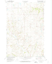
1972 Map of Fort Clark SE
USGS Topo · Published 1975About this map
Sherk Creek and the meandering Square Butte Creek define the drainage patterns of this Oliver County landscape during the early 1970s. The terrain is characterized by dissected uplands and significant elevation changes, notably marked by the prominent Ring Hill in the southeastern quadrant. This area remains largely rural, with the centrally located Yucca Cem serving as a primary cultural landmark and point of interest for genealogists tracking early families in this portion of North Dakota. The cartography reveals a highly organized township system, specifically tracking the boundary between T. 142 N. and T. 141 N. across the center of the sheet. The absence of major settlements highlights the agricultural and ranching character of the region during this era of survey.
Find a feature on this map
5 named features on this map. Tap any name to fly to it.
Don’t see what you’re looking for? This feature index may not catch every label — zoom into the map to look around manually.
Map Details
Editions of this 1972 Fort Clark SE Map
This is the sole edition of this map. No revisions or reprints were ever made.
Other maps of this area

1907 · Bismarck
USGS Topo · 1:125,000

1950 · Wilton
USGS Topo · 1:62,500

1951 · Bismarck
USGS Topo · 1:62,500

1954 · Bismarck
USGS Topo · 1:250,000

1954 · McClusky
USGS Topo · 1:250,000

1958 · Bismarck
USGS Topo · 1:250,000

1958 · McClusky
USGS Topo · 1:250,000

1962 · Harmon
USGS Topo · 1:24,000

1966 · Price
USGS Topo · 1:24,000
1966 · Sanger
USGS Topo · 1:24,000