
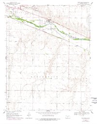
1969 Map of Fort Dodge
USGS Topo · Published 1971About this map
Fort Dodge serves as a focal point on this 1960s survey, situated along the north bank of the Arkansas River in Ford County. The map details a landscape transitioning from the industrial and agricultural activity of Dodge to the east, featuring the Atchison Topeka and Santa Fe and Chicago Rock Island and Pacific railroads. Settlement patterns are visible in the clusters at Wilroads Gardens and the Home for Boys, while the rural surroundings are divided into named areas such as Grandview, Enterprise, and Ford. Local industry is evidenced by a powerplant, a stockyard, and numerous gravel pits and sandpits, reflecting the extraction and transport economy of the era. The presence of Riverview Camp and multiple sewage disposal sites near the river provides insight into mid-century infrastructure and land use along this vital Kansas waterway.
Find a feature on this map
20 named features on this map. Tap any name to fly to it.
Don’t see what you’re looking for? This feature index may not catch every label — zoom into the map to look around manually.
Map Details
Editions of this 1969 Fort Dodge Map
2 editions found
Other maps of this area

1892 · Dodge
USGS Topo · 1:125,000

1892 · Spearville
USGS Topo · 1:125,000

1894 · Spearville
USGS Topo · 1:125,000

1955 · Pratt
USGS Topo · 1:250,000

1955 · Dodge City
USGS Topo · 1:250,000

1958 · Dodge City
USGS Topo · 1:250,000

1959 · Pratt
USGS Topo · 1:250,000

1959 · Dodge City
USGS Topo · 1:250,000

1968 · Dodge City
USGS Topo · 1:24,000
1969 · South Dodge
USGS Topo · 1:24,000