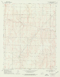
1969 Map of Fort Dodge SW
USGS Topo · Published 1977About this map
Mulberry Creek winds through the heart of this landscape, carving a drainage pattern through the townships of Enterprise, Bloom, Ford, and Wilburn. The 1969 field survey reveals a terrain defined by infrastructure and agricultural boundaries rather than dense settlements. A notable industrial presence is marked by a Compressor Station and a nearby Radio Tower, which serve as key landmarks in an otherwise open area. The presence of numerous Pipelines and a network of unimproved roads, including a dedicated Jeep Trail, underscores the region's mid-century role as a corridor for resource transport. This map captures the intersection of rural land divisions and the technological additions of the late 1960s, offering a clear view of how energy infrastructure was integrated into the High Plains environment.
Find a feature on this map
10 named features on this map. Tap any name to fly to it.
Don’t see what you’re looking for? This feature index may not catch every label — zoom into the map to look around manually.
Map Details
Editions of this 1969 Fort Dodge SW Map
2 editions found
Other maps of this area

1892 · Meade
USGS Topo · 1:125,000

1892 · Dodge
USGS Topo · 1:125,000

1892 · Spearville
USGS Topo · 1:125,000

1894 · Spearville
USGS Topo · 1:125,000

1896 · Ashland
USGS Topo · 1:125,000

1955 · Pratt
USGS Topo · 1:250,000

1955 · Dodge City
USGS Topo · 1:250,000

1958 · Dodge City
USGS Topo · 1:250,000

1959 · Pratt
USGS Topo · 1:250,000

1959 · Dodge City
USGS Topo · 1:250,000