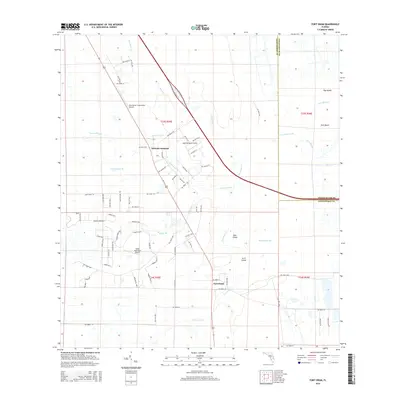
2015 Map of Fort Drum
USGS Topo · Published 2015About this map
Fort Drum and the nearby Osowaw Junction center this survey of the northern Florida interior, where a network of sloughs and creeks defines the low-lying landscape. The area is characterized by its aviation infrastructure, including the Lake Montaza Airport, Indian Hammock Airport, and the Recreation Corporation Airport. Water management and drainage patterns are evident through features like Hogskin Slough, Gum Slough, and the branching Sweetwater Br. The presence of named dry-ground elevations like Bear Island and Arch Island amidst the sloughs indicates the subtle topography of this region. Local transit is marked by a grid of rural routes such as NW 344th St and NW 338th St, while the boundary between Indian River Co and Okeechobee Co cuts through the eastern portion of the map.
Find a feature on this map
75 named features on this map. Tap any name to fly to it.
Don’t see what you’re looking for? This feature index may not catch every label — zoom into the map to look around manually.
Map Details
Editions of this 2015 Fort Drum Map
This is the sole edition of this map. No revisions or reprints were ever made.
Other maps of this area

1953 · Taylor Creek NW
USGS Topo · 1:24,000

1953 · Fort Drum
USGS Topo · 1:24,000

1953 · Fort Drum SW
USGS Topo · 1:24,000

1953 · Fort Drum NW
USGS Topo · 1:24,000

1953 · Fort Drum NE
USGS Topo · 1:24,000

1953 · Fellsmere 4 SW
USGS Topo · 1:24,000

1953 · Fellsmere 4 NW
USGS Topo · 1:24,000

1953 · Taylor Creek NE
USGS Topo · 1:24,000

1953 · Okeechobee 1 NW
USGS Topo · 1:24,000

1956 · Fort Pierce
USGS Topo · 1:250,000