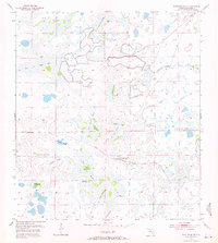
1953 Map of Fort Drum SW
USGS Topo · Published 1971About this map
Little Gumhead Marsh and a series of interconnected wetlands dominate this Okeechobee County landscape as it was documented in the early 1950s. The terrain is characterized by numerous hammocks—islands of hardwood vegetation within the marshy prairies—many bearing local family names like Thomas Hammock, Padgett Hammock, and Irvin Hammock. These elevated areas provided critical dry ground for cattle ranching and early settlement. Water management is already a visible priority on the landscape, with a system of levees constructed to control drainage across the Peat Marsh and surrounding lowlands. The survey also captures natural drainage patterns through features like Twelvemile Slough and Company Slough, while a Lookout Tower in the southeast corner provides a human landmark in this expansive wet prairie environment.
Find a feature on this map
24 named features on this map. Tap any name to fly to it.
Don’t see what you’re looking for? This feature index may not catch every label — zoom into the map to look around manually.
Map Details
Editions of this 1953 Fort Drum SW Map
3 editions found
Other maps of this area

1953 · Taylor Creek NW
USGS Topo · 1:24,000

1953 · Basinger
USGS Topo · 1:24,000

1953 · Fort Drum
USGS Topo · 1:24,000

1953 · Fort Kissimmee NE
USGS Topo · 1:24,000

1953 · Fort Drum SW
USGS Topo · 1:24,000

1953 · Fort Drum NW
USGS Topo · 1:24,000

1953 · Fort Drum NE
USGS Topo · 1:24,000

1953 · Fort Kissimmee SE
USGS Topo · 1:24,000

1953 · Taylor Creek NE
USGS Topo · 1:24,000

1956 · Fort Pierce
USGS Topo · 1:250,000