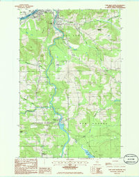
1985 Map of Fort Kent South
USGS Topo · Published 1986About this map
The St John River forms a natural international border in the northern corner of this map, separating the United States from Canada. The confluence with the south-flowing Fish River anchors the community of Fort Kent, where the landscape transitions from the concentrated residential streets of Fort Kent Village to the industrial character of Fort Kent Mills. To the south, the terrain becomes more varied with features like Stevens Hill and Michaud Hill overlooking small outlying settlements and farming operations.
Find a feature on this map
40 named features on this map. Tap any name to fly to it.
Don’t see what you’re looking for? This feature index may not catch every label — zoom into the map to look around manually.
Map Details
Editions of this 1985 Fort Kent South Map
This is the sole edition of this map. No revisions or reprints were ever made.
Other maps of this area

1927 · Square Lake
USGS Topo · 1:48,000

1928 · Eagle Lake
USGS Topo · 1:48,000

1931 · Square Lake
USGS Topo · 1:62,500

1931 · Eagle Lake
USGS Topo · 1:62,500

1932 · Frenchville
USGS Topo · 1:48,000

1932 · Fort Kent
USGS Topo · 1:48,000

1935 · Fort Kent
USGS Topo · 1:62,500

1935 · Frenchville
USGS Topo · 1:62,500

1953 · Square Lake
USGS Topo · 1:62,500

1962 · Edmundston
USGS Topo · 1:250,000