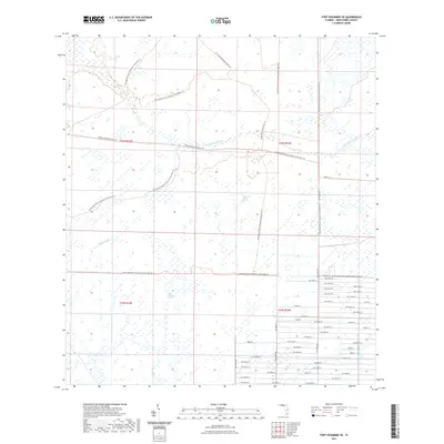
2021 Map of Fort Kissimmee SE
USGS Topo · Published 2021About this map
Sevenmile Slough winds through this section of the Florida dry prairie, defining a landscape dominated by seasonal wetlands and expansive grassy horizons. This 2021 survey illustrates the modern conservation efforts in Okeechobee County, where the Kissimmee Prairie Preserve State Park Trl provides access to one of the state's largest remaining prairie remnants. The terrain is a complex mosaic of hydrologic features, including Dead Pine Island Marsh and the isolated Wolf Sawgrass Pond, which support the region's specialized ecology. While the northern and western reaches remain largely undeveloped and crossed by the Florida National Scenic Trl, the southeastern corner shows a structured grid of rural roads, such as NW 316th St and NW 208th Ave, marking the edge of local settlement where the wilderness meets agricultural and residential development.
Find a feature on this map
51 named features on this map. Tap any name to fly to it.
Don’t see what you’re looking for? This feature index may not catch every label — zoom into the map to look around manually.
Map Details
Editions of this 2021 Fort Kissimmee SE Map
This is the sole edition of this map. No revisions or reprints were ever made.
Other maps of this area

1952 · Fort Kissimmee
USGS Topo · 1:24,000

1952 · Fort Kissimmee NW
USGS Topo · 1:24,000

1953 · Taylor Creek NW
USGS Topo · 1:24,000

1953 · Basinger
USGS Topo · 1:24,000

1953 · Fort Kissimmee NE
USGS Topo · 1:24,000

1953 · Fort Drum SW
USGS Topo · 1:24,000

1953 · Fort Drum NW
USGS Topo · 1:24,000

1953 · Basinger NW
USGS Topo · 1:24,000

1953 · Fort Kissimmee SE
USGS Topo · 1:24,000

1956 · Fort Pierce
USGS Topo · 1:250,000