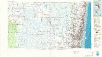
1985 Map of Fort Lauderdale
USGS Topo · Published 1986About this map
The Everglades dominate this mid-1980s landscape, revealing the sharp contrast between the conserved wetlands of the Loxahatchee National Wildlife Refuge and the rapid eastward expansion of South Florida's coastal cities. The map illustrates an intricate network of drainage and water management, defined by major arteries like the Hillsboro Canal, North New River Canal, and Miami Canal that cut through the Everglades Wildlife Management Area.
Find a feature on this map
53 named features on this map. Tap any name to fly to it.
Don’t see what you’re looking for? This feature index may not catch every label — zoom into the map to look around manually.
Map Details
Editions of this 1985 Fort Lauderdale Map
2 editions found
Other maps of this area

1945 · Fort Lauderdale North
USGS Topo · 1:24,000

1945 · Greenacres City
USGS Topo · 1:24,000

1945 · Lake Worth
USGS Topo · 1:24,000

1946 · West Dixie Bend
USGS Topo · 1:24,000

1946 · Boca Raton
USGS Topo · 1:24,000

1947 · North Miami
USGS Topo · 1:24,000

1947 · Delmar Farms
USGS Topo · 1:24,000

1949 · Lake Worth
USGS Topo · 1:24,000

1949 · Opalocka
USGS Topo · 1:24,000

1949 · Fort Lauderdale North
USGS Topo · 1:24,000