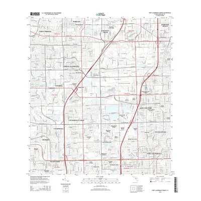
2015 Map of Fort Lauderdale North
USGS Topo · Published 2015About this map
North Lauderdale and Tamarac form part of a dense residential and commercial corridor in the northern reaches of Broward County. This 2015 survey reveals the intricate network of water management features essential to the region, including the Cypress Creek Canal and the Middle River Canal. Large-scale infrastructure like the Fort Lauderdale Executive Airport occupies a central position, while numerous neighborhood pockets such as Rock Island Village and North Andrews Gardens illustrate the post-war suburban development patterns that define the area. Several significant memorial sites, including Queen of Heaven Cem and Sunset Memorial Gardens, provide valuable markers for genealogists and local historians tracking the growth of these communities. The map also traces the varied water bodies from Lazy Lake to Rock Pit Lake, showing how the landscape has been engineered to accommodate rapid urban expansion.
Find a feature on this map
78 named features on this map. Tap any name to fly to it.
Don’t see what you’re looking for? This feature index may not catch every label — zoom into the map to look around manually.
Map Details
Editions of this 2015 Fort Lauderdale North Map
This is the sole edition of this map. No revisions or reprints were ever made.
Other maps of this area

1945 · Fort Lauderdale North
USGS Topo · 1:24,000

1946 · West Dixie Bend
USGS Topo · 1:24,000

1946 · Boca Raton
USGS Topo · 1:24,000

1949 · Fort Lauderdale North
USGS Topo · 1:24,000

1949 · West Dixie Bend
USGS Topo · 1:24,000

1949 · Port Everglades
USGS Topo · 1:24,000

1949 · Fort Lauderdale South
USGS Topo · 1:24,000

1949 · Pompano Beach
USGS Topo · 1:24,000

1950 · Boca Raton
USGS Topo · 1:24,000

1956 · West Palm Beach
USGS Topo · 1:250,000