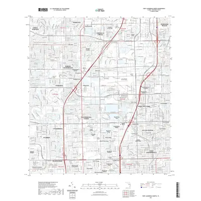
2021 Map of Fort Lauderdale North
USGS Topo · Published 2021About this map
Fort Lauderdale and its northern suburbs are defined here by a dense grid of residential developments and a complex network of waterways, including the Cypress Creek Canal and the Middle River Canal. The landscape is a sprawling mosaic of established neighborhoods like North Lauderdale, Lauderhill, and Sunrise, interspersed with large-scale memorial sites such as Star of David Memorial Gardens and Our Lady Queen of Heaven Cem. Significant educational and transportation infrastructure anchors the region, notably the Fort Lauderdale Executive Airport and Broward College North Campus. The presence of specialized recreation, like the Wilton Manors Designated Paddling Trl, highlights the area's transition into a modern metropolitan environment where residential life is intricately woven around drainage and transit corridors.
Find a feature on this map
83 named features on this map. Tap any name to fly to it.
Don’t see what you’re looking for? This feature index may not catch every label — zoom into the map to look around manually.
Map Details
Editions of this 2021 Fort Lauderdale North Map
This is the sole edition of this map. No revisions or reprints were ever made.
Other maps of this area

1945 · Fort Lauderdale North
USGS Topo · 1:24,000

1946 · West Dixie Bend
USGS Topo · 1:24,000

1946 · Boca Raton
USGS Topo · 1:24,000

1949 · Fort Lauderdale North
USGS Topo · 1:24,000

1949 · West Dixie Bend
USGS Topo · 1:24,000

1949 · Port Everglades
USGS Topo · 1:24,000

1949 · Fort Lauderdale South
USGS Topo · 1:24,000

1949 · Pompano Beach
USGS Topo · 1:24,000

1950 · Boca Raton
USGS Topo · 1:24,000

1956 · West Palm Beach
USGS Topo · 1:250,000