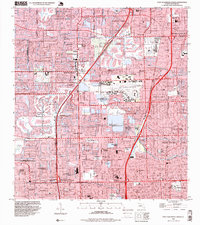
1995 Map of Fort Lauderdale North
USGS Topo · Published 1999About this map
Florida's Turnpike and Atlantic Boulevard anchor this mid-1990s snapshot of Broward County's rapid suburbanization. The landscape is a complex geometry of water and residential planning, featuring numerous developments like Sabal Palms Estates, Rock Island Village, and Jenada Isles. This era shows the extensive network of canals and waterways, including the Middle River and Cypress Creek, that define the region's topography and drainage.
Find a feature on this map
83 named features on this map. Tap any name to fly to it.
Don’t see what you’re looking for? This feature index may not catch every label — zoom into the map to look around manually.
Map Details
Editions of this 1995 Fort Lauderdale North Map
This is the sole edition of this map. No revisions or reprints were ever made.
Other maps of this area

1945 · Fort Lauderdale North
USGS Topo · 1:24,000

1946 · West Dixie Bend
USGS Topo · 1:24,000

1946 · Boca Raton
USGS Topo · 1:24,000

1949 · Fort Lauderdale North
USGS Topo · 1:24,000

1949 · West Dixie Bend
USGS Topo · 1:24,000

1949 · Port Everglades
USGS Topo · 1:24,000

1949 · Fort Lauderdale South
USGS Topo · 1:24,000

1949 · Pompano Beach
USGS Topo · 1:24,000

1950 · Boca Raton
USGS Topo · 1:24,000

1956 · West Palm Beach
USGS Topo · 1:250,000