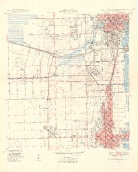
1949 Map of Fort Lauderdale South
USGS Topo · Published 1949About this map
The Seminole Indian Reservation and the burgeoning coastlines of South Florida define this late-1940s landscape. Industrial and maritime development is centered at Port Everglades, while the residential grid expands through Dania and Hollywood. The map reveals a transition from the structured street grids near the Florida East Coast railroad to the rural reaches of Davie, where the Davie Airport and early drainage structures like the New River Canal dominate.
Find a feature on this map
48 named features on this map. Tap any name to fly to it.
Don’t see what you’re looking for? This feature index may not catch every label — zoom into the map to look around manually.
Map Details
Editions of this 1949 Fort Lauderdale South Map
2 editions found
Other maps of this area

1945 · Fort Lauderdale North
USGS Topo · 1:24,000

1947 · North Miami
USGS Topo · 1:24,000

1949 · Opalocka
USGS Topo · 1:24,000

1949 · Fort Lauderdale North
USGS Topo · 1:24,000

1949 · Port Everglades
USGS Topo · 1:24,000

1949 · Fort Lauderdale South
USGS Topo · 1:24,000

1949 · Pompano Beach
USGS Topo · 1:24,000

1950 · North Miami
USGS Topo · 1:24,000

1956 · Miami
USGS Topo · 1:250,000

1956 · West Palm Beach
USGS Topo · 1:250,000