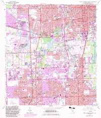
1962 Map of Fort Lauderdale South
USGS Topo · Published 1983About this map
Urban expansion and mid-century suburbanization define this 1962 landscape, with 1980s updates showing the rapid growth of Fort Lauderdale, Hollywood, and Dania. The central portion of the map is dominated by the Fort Lauderdale-Hollywood International Airport and the complex industrial infrastructure surrounding Port Everglades, including the Dania Cut-Off Canal and numerous substations. This period captures a transition in South Florida’s development, where early 20th-century agriculture and drainage projects made way for dense residential enclaves like Plantation Isles, Hacienda Village, and Driftwood Acres.
Find a feature on this map
111 named features on this map. Tap any name to fly to it.
Don’t see what you’re looking for? This feature index may not catch every label — zoom into the map to look around manually.
Map Details
Editions of this 1962 Fort Lauderdale South Map
3 editions found
Other maps of this area

1945 · Fort Lauderdale North
USGS Topo · 1:24,000

1947 · North Miami
USGS Topo · 1:24,000

1949 · Opalocka
USGS Topo · 1:24,000

1949 · Fort Lauderdale North
USGS Topo · 1:24,000

1949 · Port Everglades
USGS Topo · 1:24,000

1949 · Fort Lauderdale South
USGS Topo · 1:24,000

1949 · Pompano Beach
USGS Topo · 1:24,000

1950 · North Miami
USGS Topo · 1:24,000

1956 · Miami
USGS Topo · 1:250,000

1956 · West Palm Beach
USGS Topo · 1:250,000