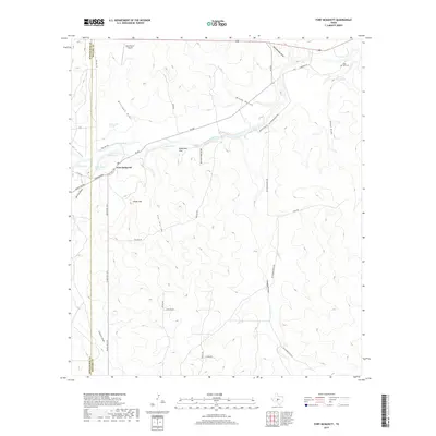
2019 Map of Fort McKavett
USGS Topo · Published 2019About this map
Fort McKavett serves as the focal point of this Central Texas landscape, situated near the headwaters of the San Saba River. The area is characterized by a network of seasonal watercourses and drainage features, including Milligan Draw, Butcher Pen Draw, and Rattlesnake Draw. Settlement patterns are sparse, with the presence of Robertson Flat and the Herd Ranch Airport indicating the expansive ranching operations of the Edwards Plateau. Traces of historical movement through the terrain are preserved in the labeling of the Toe Nail Trl, while local water sources like Government Springs, Baptism Hole, and Calistro Hole highlight the importance of dependable springs in this semi-arid region. The map also identifies the Bihl Cem to the northeast, a key site for local genealogical research.
Find a feature on this map
39 named features on this map. Tap any name to fly to it.
Don’t see what you’re looking for? This feature index may not catch every label — zoom into the map to look around manually.
Map Details
Editions of this 2019 Fort McKavett Map
This is the sole edition of this map. No revisions or reprints were ever made.
Other maps of this area

1893 · Fort McKavett
USGS Topo · 1:125,000

1954 · Llano
USGS Topo · 1:250,000

1954 · Sonora
USGS Topo · 1:250,000

1955 · Llano
USGS Topo · 1:250,000

1956 · Llano
USGS Topo · 1:250,000

1958 · Sonora
USGS Topo · 1:250,000
1963 · Coal Kiln Draw
USGS Topo · 1:24,000

1963 · McKegan Draw NE
USGS Topo · 1:24,000

1970 · Clear Creek Lake
USGS Topo · 1:24,000

1970 · San Augustine Draw
USGS Topo · 1:24,000