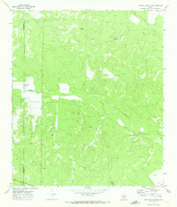
1970 Map of Fort McKavett NE
USGS Topo · Published 1973About this map
Rocky Creek winds through the limestone uplands of the Edwards Plateau in this 1970 survey of the Menard and Schleicher County border. The landscape is defined by the extraction of natural resources and large-scale ranching, with numerous labels for Oil Well and Gas Well sites alongside a network of Gravel Pit operations. Isolated outposts such as White Ranch and Russell Ranch punctuate the drainage basins, while livestock reliance on scattered water sources is evidenced by the named Ninemile Waterhole. The map effectively captures the transition from the rugged drainage of Brown Hollow and Milligan Draw to the high ground of Round Hill. These features reveal a mid-century Texas backcountry where the traditional ranching economy was increasingly overlaid by the infrastructure of the energy industry, connected by a web of unimproved roads and fence lines.
Find a feature on this map
14 named features on this map. Tap any name to fly to it.
Don’t see what you’re looking for? This feature index may not catch every label — zoom into the map to look around manually.
Map Details
Editions of this 1970 Fort McKavett NE Map
2 editions found
Other maps of this area

1892 · San Angelo
USGS Topo · 1:125,000

1892 · Eden
USGS Topo · 1:125,000

1893 · Fort McKavett
USGS Topo · 1:125,000

1896 · Eden
USGS Topo · 1:125,000

1954 · Brownwood
USGS Topo · 1:250,000

1954 · Llano
USGS Topo · 1:250,000

1954 · Sonora
USGS Topo · 1:250,000

1954 · San Angelo
USGS Topo · 1:250,000

1955 · Llano
USGS Topo · 1:250,000

1956 · Llano
USGS Topo · 1:250,000