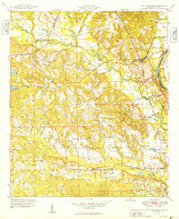
1949 Map of Fort Mitchell
USGS Topo · Published 1949About this map
The Fort Benning Military Reservation occupies the eastern portion of this landscape along the Chattahoochee River, where the state line divides Alabama and Georgia. This post-war period captures a transition in the local economy, as the Central of Georgia railroad follows the winding path of Cowpen Creek through the rugged interior hills. In the southern reach of the survey, the rural settlement of Oswichee is visible with its local Cem and schools, while the more prominent Fort Mitchell sits north of the junction of Uchee Creek. The map documents a terrain defined by numerous waterways including Igahee Creek and Sevenmile, illustrating the complex drainage of the river basin. Cultural landmarks like Kite Sch and the Radio Towers punctuate the ridges, and Bradley Landing marks an important historical point of river access.
Find a feature on this map
25 named features on this map. Tap any name to fly to it.
Don’t see what you’re looking for? This feature index may not catch every label — zoom into the map to look around manually.
Map Details
Editions of this 1949 Fort Mitchell Map
2 editions found
Other maps of this area

1908 · Columbus
USGS Topo · 1:62,500

1914 · Seale
USGS Topo · 1:62,500

1929 · Columbus
USGS Topo · 1:48,000

1947 · Columbus
USGS Topo · 1:62,500

1949 · Fort Mitchell
USGS Topo · 1:24,000

1949 · Julia
USGS Topo · 1:24,000

1949 · Columbus
USGS Topo · 1:24,000

1950 · Fort Benning
USGS Topo · 1:24,000

1950 · Crawford
USGS Topo · 1:24,000

1950 · Seale
USGS Topo · 1:24,000