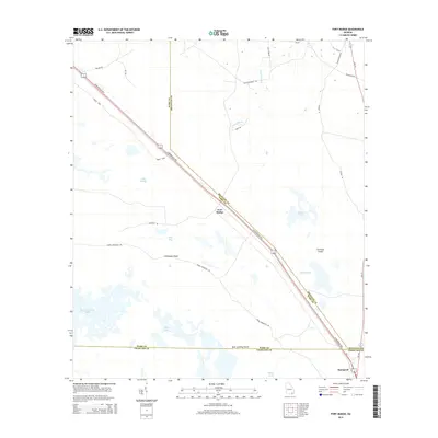
2014 Map of Fort Mudge
USGS Topo · Published 2014About this map
Fort Mudge and the community of Racepond anchor this portion of Georgia's coastal plain, where the landscape is defined by the intersection of Ware, Brantley, and Charlton counties. The Jacksonville Hwy cuts a straight path southeast through a complex wetland system of sloughs and bays. The topography is characterized by slightly elevated "islands" such as Cowhouse Island, Corncob Island, and Boat Landing Island, which provide stable ground amidst the surrounding waters of Wide Slough and Poke Bay. Deepwater features like Maul-Hammock Lake, Ohio Lake, and Marys Lake dot the southern reaches of the map, suggesting a landscape that remains closely tied to its natural hydrology. Transportation routes like Swamp Perimeter Rd and Old Racepond Rd follow the terrain's dry edges, reflecting the historical movement of residents around the extensive swampy lowlands of the region.
Find a feature on this map
33 named features on this map. Tap any name to fly to it.
Don’t see what you’re looking for? This feature index may not catch every label — zoom into the map to look around manually.
Map Details
Editions of this 2014 Fort Mudge Map
This is the sole edition of this map. No revisions or reprints were ever made.
Other maps of this area

1918 · Folkston
USGS Topo · 1:62,500

1953 · Waycross
USGS Topo · 1:250,000

1954 · Valdosta
USGS Topo · 1:250,000

1958 · Valdosta
USGS Topo · 1:250,000

1958 · Waycross
USGS Topo · 1:250,000

1959 · Valdosta
USGS Topo · 1:250,000

1965 · Double Lakes
USGS Topo · 1:24,000

1965 · Dinner Pond
USGS Topo · 1:24,000
1966 · Winokur
USGS Topo · 1:24,000
1966 · Newell
USGS Topo · 1:24,000