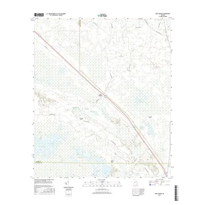
2017 Map of Fort Mudge
USGS Topo · Published 2017About this map
Fort Mudge sits at the transition between Georgia's coastal plain and the vast wetlands to the south. This 2017 survey details the northern reaches of the Okefenokee Swamp, where the landscape is defined by a mosaic of named islands and aquatic prairies. Distinctive features like Cowhouse Island, Corncob Island, and Boat Landing Island rise above the surrounding waters of Maul Hammock Prairie and Green Swamp, indicating slightly higher ground in an otherwise saturated environment. The road network, including Crews Blvd and Swamp Perimeter Rd, outlines the perimeter of this protected wilderness. In the northern section, drainage features like S Prong Big Cr and Wide Slough show the intricate hydrology that feeds into the swamp, while smaller water bodies like Ohio Lake and Perch Lake dot the interior, illustrating the area's complex freshwater ecosystem.
Find a feature on this map
29 named features on this map. Tap any name to fly to it.
Don’t see what you’re looking for? This feature index may not catch every label — zoom into the map to look around manually.
Map Details
Editions of this 2017 Fort Mudge Map
This is the sole edition of this map. No revisions or reprints were ever made.
Other maps of this area

1918 · Folkston
USGS Topo · 1:62,500

1953 · Waycross
USGS Topo · 1:250,000

1954 · Valdosta
USGS Topo · 1:250,000

1958 · Valdosta
USGS Topo · 1:250,000

1958 · Waycross
USGS Topo · 1:250,000

1959 · Valdosta
USGS Topo · 1:250,000

1965 · Double Lakes
USGS Topo · 1:24,000

1965 · Dinner Pond
USGS Topo · 1:24,000
1966 · Winokur
USGS Topo · 1:24,000
1966 · Newell
USGS Topo · 1:24,000