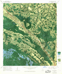
1967 Map of Fort Mudge
USGS Topo · Published 1968About this map
Okefenokee Swamp dominates this late-1960s photomap, revealing a complex environment of islands, sloughs, and blackwater lakes at the intersection of Ware, Brantley, and Charlton counties. The landscape transitions from the managed timberlands of Waycross State Forest in the northwest to the protected wilderness of the Okefenokee National Wildlife Refuge. Notable features such as Cowhouse Island and Billy Landing Island rise above the wetlands, which are crisscrossed by a boat trail and a dismantled logging tram, marking the area's history of extraction and recreation.
Find a feature on this map
39 named features on this map. Tap any name to fly to it.
Don’t see what you’re looking for? This feature index may not catch every label — zoom into the map to look around manually.
Map Details
Editions of this 1967 Fort Mudge Map
This is the sole edition of this map. No revisions or reprints were ever made.
Other maps of this area

1918 · Folkston
USGS Topo · 1:62,500

1953 · Waycross
USGS Topo · 1:250,000

1954 · Valdosta
USGS Topo · 1:250,000

1958 · Valdosta
USGS Topo · 1:250,000

1958 · Waycross
USGS Topo · 1:250,000

1959 · Valdosta
USGS Topo · 1:250,000

1965 · Double Lakes
USGS Topo · 1:24,000

1965 · Dinner Pond
USGS Topo · 1:24,000
1966 · Winokur
USGS Topo · 1:24,000
1966 · Newell
USGS Topo · 1:24,000