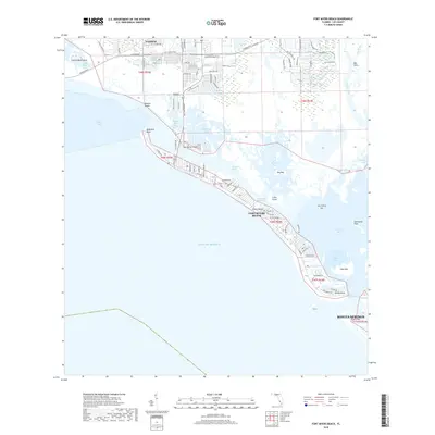
2018 Map of Fort Myers Beach
USGS Topo · Published 2018About this map
Fort Myers Beach sits at the heart of this coastal study, stretching along the thin barrier islands of the Gulf of Mexico. This 2018 survey detail provides a clear view of the dense residential development and road networks that define the Lee County shoreline just before the close of the decade. The landscape is a complex maze of waterways including the Intracoastal Waterway, Matanzas Pass, and Hell Peckney Bay, which separate the primary beach communities from inland areas like Truckland and San Carlos Island.
Find a feature on this map
93 named features on this map. Tap any name to fly to it.
Don’t see what you’re looking for? This feature index may not catch every label — zoom into the map to look around manually.
Map Details
Editions of this 2018 Fort Myers Beach Map
This is the sole edition of this map. No revisions or reprints were ever made.
Other maps of this area

1956 · West Palm Beach
USGS Topo · 1:250,000

1956 · Tampa
USGS Topo · 1:250,000
1956 · Charlotte Harbor
USGS Topo · 1:250,000

1957 · West Palm Beach
USGS Topo · 1:250,000
1958 · West Palm Beach
USGS Topo · 1:250,000
1958 · Bonita Springs
USGS Topo · 1:24,000
1958 · Estero
USGS Topo · 1:24,000
1958 · Fort Myers SW
USGS Topo · 1:24,000
1958 · Sanibel
USGS Topo · 1:24,000
1958 · Pine Island Center
USGS Topo · 1:24,000