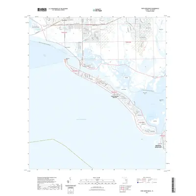
2021 Map of Fort Myers Beach
USGS Topo · Published 2021About this map
Fort Myers Beach and the barrier islands of Lee County are mapped here in a detailed modern survey, revealing the intricate geography of the Gulf coast's aquatic preserves. The landscape is defined by complex tidal channels and named features like Matanzas Pass, Hurricane Bay, and Hell Peckney Bay, which separate the developed resort areas from protected mangrove environments. On the mainland, the map tracks the growth of Truckland and the southern reaches of Bonita Springs, connected by major corridors such as Summerlin Rd and Estero Blvd. This coastal survey highlights the balance between residential development and the preserved shoreline at Bunche Beach and Lovers Key. It also serves as a guide for modern navigation, tracing the path of the Florida Circumnavigational Paddling Trl through the Intracoastal Waterway and across San Carlos Bay.
Find a feature on this map
40 named features on this map. Tap any name to fly to it.
Don’t see what you’re looking for? This feature index may not catch every label — zoom into the map to look around manually.
Map Details
Editions of this 2021 Fort Myers Beach Map
This is the sole edition of this map. No revisions or reprints were ever made.
Other maps of this area

1956 · West Palm Beach
USGS Topo · 1:250,000

1956 · Tampa
USGS Topo · 1:250,000

1956 · Charlotte Harbor
USGS Topo · 1:250,000

1957 · West Palm Beach
USGS Topo · 1:250,000

1958 · West Palm Beach
USGS Topo · 1:250,000

1958 · Bonita Springs
USGS Topo · 1:24,000

1958 · Estero
USGS Topo · 1:24,000

1958 · Fort Myers SW
USGS Topo · 1:24,000

1958 · Sanibel
USGS Topo · 1:24,000

1958 · Pine Island Center
USGS Topo · 1:24,000