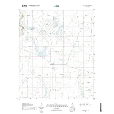
2018 Map of Fort Necessity
USGS Topo · Published 2018About this map
Fort Necessity and Buie anchor this rural landscape in Franklin Parish, where the geography is defined by a dense network of slow-moving bayous and drainage sloughs. The area is marked by numerous family and community burial grounds, including the Fort Necessity Cem, Saint Paul Cem, and Boeuf Prairie Cem, reflecting a long-established settlement pattern along the watercourses. The terrain is a complex of wetlands and small streams such as Goose Cr, Grayson Bayou, and Big Grassy Bayou, which snake through the agricultural fields and forested patches. In the southern portion, Turkey Cr Lake and the Circle G Airport stand out as notable landmarks within the largely rural layout. The map's detail provides a look at the local road network, showing family-named routes like Asa Knox Rd and J J Hatton Rd that connect these dispersed communities.
Find a feature on this map
81 named features on this map. Tap any name to fly to it.
Don’t see what you’re looking for? This feature index may not catch every label — zoom into the map to look around manually.
Map Details
Editions of this 2018 Fort Necessity Map
This is the sole edition of this map. No revisions or reprints were ever made.
Other maps of this area

1935 · Winnsboro
USGS Topo · 1:62,500

1939 · Fort Necessity
USGS Topo · 1:62,500

1941 · Sicily Island
USGS Topo · 1:62,500

1941 · Harrisonburg
USGS Topo · 1:62,500

1953 · Natchez
USGS Topo · 1:250,000

1955 · Jackson
USGS Topo · 1:250,000

1956 · Natchez
USGS Topo · 1:250,000

1957 · Sicily Island
USGS Topo · 1:62,500

1958 · Winnsboro
USGS Topo · 1:62,500

1958 · Fort Necessity
USGS Topo · 1:62,500