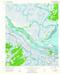
1955 Map of Fort Pulaski
USGS Topo · Published 1957About this map
Fort Pulaski National Monument commands the entrance to the Savannah River, marking a strategic coastal landscape defined by shifting sands and intricate tidal channels. In the mid-1950s, the area shows a distinct contrast between the developed residential patterns of Wilmington Island and Whitemarsh Island and the isolated maritime character of Daufuskie Island. The coastal economy and navigation are traced through the Intracoastal Waterway, linking deep-water paths like South Channel with engineered passages such as Walls Cut and Fields Cut. On Daufuskie Island, localized communal life is centered around Union Ch, Mary Field Sch, and Mary Field Cem. Evidence of changing technology appears in an Airport (Abandoned) on Wilmington Island and an Lighthouse (Abandoned) on Cockspur Island, while the Savannah National Wildlife Refuge preserves the natural marshlands of the Savannah River estuary.
Find a feature on this map
47 named features on this map. Tap any name to fly to it.
Don’t see what you’re looking for? This feature index may not catch every label — zoom into the map to look around manually.
Map Details
Editions of this 1955 Fort Pulaski Map
2 editions found
Other maps of this area

1920 · Wassaw Sound
USGS Topo · 1:62,500

1920 · Bluffton
USGS Topo · 1:62,500

1942 · Savannah
USGS Topo · 1:62,500

1944 · Ossabaw Island
USGS Topo · 1:62,500

1945 · Bluffton
USGS Topo · 1:62,500

1945 · Ossabaw Island
USGS Topo · 1:62,500

1945 · Wassaw Sound
USGS Topo · 1:62,500

1946 · Brunswick
USGS Topo · 1:250,000

1947 · Savannah
USGS Topo · 1:250,000

1948 · Brunswick
USGS Topo · 1:250,000