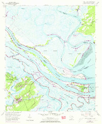
1955 Map of Fort Pulaski
USGS Topo · Published 1973About this map
Fort Pulaski National Monument stands as the central landmark of this coastal survey, occupying Cockspur Island at the mouth of the Savannah River. The map captures a complex maritime landscape of salt marshes and tidal waterways where South Carolina and Georgia meet, defined by engineered passages like Fields Cut and Walls Cut. On Daufuskie Island, the presence of Union Ch, Mary Field Sch, and Mary Field Cem provides a detailed look at the established community life on these sea islands during the mid-20th century.
Find a feature on this map
43 named features on this map. Tap any name to fly to it.
Don’t see what you’re looking for? This feature index may not catch every label — zoom into the map to look around manually.
Map Details
Editions of this 1955 Fort Pulaski Map
2 editions found
Other maps of this area

1920 · Wassaw Sound
USGS Topo · 1:62,500

1920 · Bluffton
USGS Topo · 1:62,500

1942 · Savannah
USGS Topo · 1:62,500

1944 · Ossabaw Island
USGS Topo · 1:62,500

1945 · Bluffton
USGS Topo · 1:62,500

1945 · Ossabaw Island
USGS Topo · 1:62,500

1945 · Wassaw Sound
USGS Topo · 1:62,500

1946 · Brunswick
USGS Topo · 1:250,000

1947 · Savannah
USGS Topo · 1:250,000

1948 · Brunswick
USGS Topo · 1:250,000