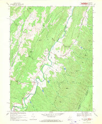
1969 Map of Fort Seybert
USGS Topo · Published 1970About this map
South Fork Potomac River carves a narrow, winding valley through this part of Pendleton County, West Virginia, at a time when small rural settlements like Fort Seybert and Brandywine served as the primary social and economic hubs. The landscape is defined by its deep verticality, where ridges such as Brushy Mtn and River Ridge separate isolated communities. Local life is anchored by country churches including Fairview Bethel Ch and New Bethlehem Ch, while numerous cemeteries scattered across the slopes indicate the long-standing family roots in this corner of the Appalachian mountains. A series of water management structures, such as Dam No 10 and Dam No 11, highlight efforts to control the runoff from the high peaks of the George Washington National Forest. Tracing these drainage patterns from Rough Run to Stony Run reveals the intricate network of hollows that once dictated the placement of roads and homesteads.
Find a feature on this map
65 named features on this map. Tap any name to fly to it.
Don’t see what you’re looking for? This feature index may not catch every label — zoom into the map to look around manually.
Map Details
Editions of this 1969 Fort Seybert Map
2 editions found
Other maps of this area

1892 · Franklin
USGS Topo · 1:125,000

1896 · Franklin
USGS Topo · 1:125,000

1920 · Petersburg
USGS Topo · 1:48,000

1920 · Onego
USGS Topo · 1:62,500

1921 · Petersburg
USGS Topo · 1:48,000

1921 · Onego
USGS Topo · 1:48,000

1922 · Onego
USGS Topo · 1:62,500

1922 · Fort Seybert
USGS Topo · 1:48,000

1922 · Petersburg
USGS Topo · 1:62,500

1922 · Circleville
USGS Topo · 1:62,500