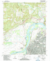
1987 Map of Fort Smith
USGS Topo · Published 1990About this map
The Arkansas River serves as a defining boundary in this late-1980s landscape, separating Fort Smith and Van Buren from the western lowlands of Moffett Bottom across the state line in Oklahoma. The urban grid of Fort Smith is densely packed with local institutions, including numerous schools like North Side High Sch and St Johns Sch, alongside spiritual landmarks such as Immaculate Conception Sch and Gospel Tabernacle. The convergence of the Poteau River with the Arkansas highlights a legacy of river navigation and industry, evidenced by multiple gaging stations and sewage treatment facilities.
Find a feature on this map
80 named features on this map. Tap any name to fly to it.
Don’t see what you’re looking for? This feature index may not catch every label — zoom into the map to look around manually.
Map Details
Editions of this 1987 Fort Smith Map
2 editions found
Other maps of this area

1879 · Fort Smith
USGS Topo · 1:62,500

1887 · Van Buren
USGS Topo · 1:62,500

1890 · Fort Smith
USGS Topo · 1:125,000

1898 · Winslow #3
USGS Topo · 1:62,500

1898 · Tahlequah
USGS Topo · 1:125,000

1898 · Winslow
USGS Topo · 1:125,000

1900 · Sallisaw
USGS Topo · 1:125,000

1901 · Winslow
USGS Topo · 1:125,000

1901 · Tahlequah
USGS Topo · 1:125,000

1905 · Tahlequah
USGS Topo · 1:125,000