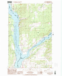
1985 Map of Fort Spokane
USGS Topo · Published 1985About this map
The confluence of the Columbia River and Spokane River dominates this landscape, where the waters of Franklin D Roosevelt Lake meet the historic grounds of Fort Spokane. This mid-1980s survey illustrates a complex boundary zone where the Spokane Indian Reservation, Colville Indian Reservation, and the Coulee Dam National Recreation Area converge. The terrain is marked by distinctive geological formations like Castle Rock and Mitre Rock, which overlook the submerged canyons and bays. Small settlements and isolated outposts like Miles, Lincoln, and the community of Egypt are connected by a network of unimproved roads and trails. Evidence of local infrastructure includes a Landing Strip and the U.S. Youth Conservation Camp, reflecting the area's dual role as a managed natural resource and a site of federal administration.
Find a feature on this map
30 named features on this map. Tap any name to fly to it.
Don’t see what you’re looking for? This feature index may not catch every label — zoom into the map to look around manually.
Map Details
Editions of this 1985 Fort Spokane Map
This is the sole edition of this map. No revisions or reprints were ever made.
Other maps of this area

1948 · Hunters
USGS Topo · 1:62,500

1948 · Wilmont Creek
USGS Topo · 1:62,500

1948 · Lincoln
USGS Topo · 1:62,500

1948 · Turtle Lake
USGS Topo · 1:62,500

1950 · Lincoln
USGS Topo · 1:62,500

1950 · Turtle Lake
USGS Topo · 1:62,500

1950 · Wilmont Creek
USGS Topo · 1:62,500

1950 · Hunters
USGS Topo · 1:62,500

1953 · Ritzville
USGS Topo · 1:250,000

1954 · Okanogan
USGS Topo · 1:250,000