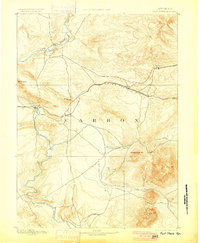
1893 Map of Fort Steele
USGS Topo · Published 1900About this map
The North Platte River winds through the high Wyoming terrain in this late nineteenth-century reconnaissance, dominated by the crucial corridor of the Union Pacific Ry. Topographer Willard D. Johnson and geographer A.H. Thompson documented the region as coal mining and rail infrastructure defined its emerging economy. Settlement patterns follow the iron rail, from the mining center at Hanna to the remote siding at Dana. The map captures the significant elevation changes of the Carbon County landscape, anchoring the eastern view with the towering presence of Elk Mt and Sheephead Mt. Along the river, the post of Fort Steele serves as a historic waypoint where the rail line crosses the water, while smaller stops like Walcott and St Mary mark the transition between the river valley and the high plains. Tributaries such as Rattlesnake Creek and Pass Creek drain the slopes of the surrounding peaks, illustrating the vital water network in this arid environment.
Find a feature on this map
18 named features on this map. Tap any name to fly to it.
Don’t see what you’re looking for? This feature index may not catch every label — zoom into the map to look around manually.
Map Details
Editions of this 1893 Fort Steele Map
4 editions found
Other maps of this area

1893 · Fort Steele
USGS Topo · 1:125,000

1906 · Medicine Bow
USGS Topo · 1:125,000

1908 · Medicine Bow
USGS Topo · 1:125,000

1914 · Hanna
USGS Topo · 1:62,500

1914 · Walcott
USGS Topo · 1:62,500

1914 · Saddleback Hills
USGS Topo · 1:62,500

1921 · Saddleback Hills
USGS Topo · 1:62,500

1932 · Savery
USGS Topo · 1:96,000

1939 · Saratoga
USGS Topo · 1:125,000

1940 · Savery
USGS Topo · 1:125,000