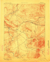
1893 Map of Fort Steele
USGS Topo · Published 1913About this map
The Union Pacific Ry carves through the central high country of Carbon County, Wyoming, in this late 19th-century reconnaissance survey. This transit corridor follows the natural logic of the terrain, connecting isolated stations like Dana, Percy, and Walcott to the coal-rich settlement of Hanna. Near the western edge of the map, Fort Steele sits strategically where the railroad crosses the North Platte River, a vital water source that winds through the southern elevations. The landscape is dominated by massive peaks including Elk Mt, Sheephead Mt, and Cedar Mt, while a network of drainage systems like Pass Creek and Rattlesnake Creek define the rugged local geography. The map captures the infrastructure of the frontier at a time when the railroad served as the primary lifeline for development in the Wyoming Territory.
Find a feature on this map
18 named features on this map. Tap any name to fly to it.
Don’t see what you’re looking for? This feature index may not catch every label — zoom into the map to look around manually.
Map Details
Editions of this 1893 Fort Steele Map
4 editions found
Other maps of this area

1893 · Fort Steele
USGS Topo · 1:125,000

1906 · Medicine Bow
USGS Topo · 1:125,000

1908 · Medicine Bow
USGS Topo · 1:125,000

1914 · Hanna
USGS Topo · 1:62,500

1914 · Walcott
USGS Topo · 1:62,500

1914 · Saddleback Hills
USGS Topo · 1:62,500

1921 · Saddleback Hills
USGS Topo · 1:62,500

1932 · Savery
USGS Topo · 1:96,000

1939 · Saratoga
USGS Topo · 1:125,000

1940 · Savery
USGS Topo · 1:125,000