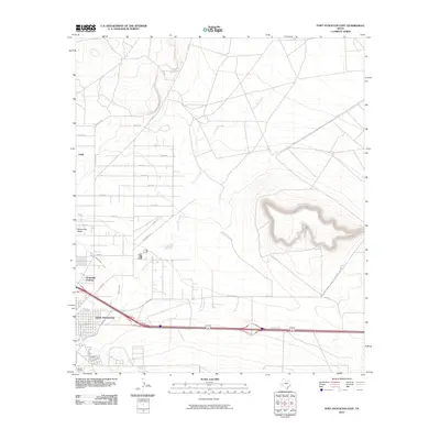
2010 Map of Fort Stockton East
USGS Topo · Published 2010About this map
Fort Stockton serves as the focal point of this West Texas survey, where the urban grid meets the arid expanses of the Trans-Pecos. The geography is defined by the prominent relief of Sevenmile Mesa and the winding course of Comanche Creek, which meanders through the landscape alongside the Highline Ditch. This era shows the continued expansion of the city's outskirts, including the residential clusters of Bodieville Colonia and the small settlement of Guild to the northwest. The map provides a detailed look at the local infrastructure, from the industrial zones along Industrial Rd to the established East Hill Cemetery on the southern edge of town. A complex network of local routes like Stone Rd and Seven D Rd reveals how the community has integrated with the natural terrain of the surrounding plateau.
Find a feature on this map
29 named features on this map. Tap any name to fly to it.
Don’t see what you’re looking for? This feature index may not catch every label — zoom into the map to look around manually.
Map Details
Editions of this 2010 Fort Stockton East Map
This is the sole edition of this map. No revisions or reprints were ever made.
Other maps of this area

1921 · Fort Stockton
USGS Topo · 1:62,500

1923 · Fort Stockton
USGS Topo · 1:62,500

1928 · Comanche Spring
USGS Topo · 1:125,000

1954 · Pecos
USGS Topo · 1:250,000

1954 · Fort Stockton
USGS Topo · 1:250,000

1957 · Pecos
USGS Topo · 1:250,000

1958 · Fort Stockton
USGS Topo · 1:250,000

1970 · Fort Stockton West
USGS Topo · 1:24,000

1970 · Twelvemile Mesa
USGS Topo · 1:24,000

1970 · East Mesa
USGS Topo · 1:24,000