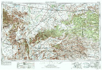
1954 Map of Fort Stockton
USGS Topo · Published 1974About this map
Fort Stockton serves as the focal point of this Trans-Pecos survey, illustrating a landscape defined by expansive ranching draws and the volcanic profiles of the Barrila Mountains and Glass Mountains. The map traces the critical transportation corridors of the mid-20th century, including the early development of Interstate 10 and the established routes of the Southern Pacific and Atchison Topeka and Santa Fe railroads.
Find a feature on this map
70 named features on this map. Tap any name to fly to it.
Don’t see what you’re looking for? This feature index may not catch every label — zoom into the map to look around manually.
Map Details
Editions of this 1954 Fort Stockton Map
3 editions found

Other maps of this area

1894 · Valentine
USGS Topo · 1:125,000

1894 · Fort Davis
USGS Topo · 1:125,000

1895 · Marfa
USGS Topo · 1:125,000

1895 · Alpine
USGS Topo · 1:125,000

1896 · Shafter
USGS Topo · 1:125,000

1897 · Valentine
USGS Topo · 1:125,000

1897 · Fort Davis
USGS Topo · 1:125,000

1917 · Santiago Peak
USGS Topo · 1:62,500

1917 · Buck Hill
USGS Topo · 1:62,500

1917 · Hood Spring
USGS Topo · 1:62,500