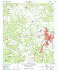
1973 Map of Fort Valley West
USGS Topo · Published 1985About this map
The railroad junction at Fort Valley serves as the focal point for this mid-Georgia survey, where the Southern and Central of Georgia lines intersect. The map documents the city's infrastructure during a period of growth, detailing the campus of Fort Valley State College and the local street grid featuring Magnolia St and College St. To the northwest, the rural landscape of Peach and Crawford counties is dotted with small settlements like Zenith and Lee Pope, along with numerous family and church burial grounds including Ross Chapel Cem and Gassick Cem. This edition includes purple photogrammetric revisions that highlight changes in the built environment between the original 1973 field check and 1985. Notable landmarks such as the County Hospital and the Radio Tower (WFPM) anchor the town's social geography during the late twentieth century.
Find a feature on this map
54 named features on this map. Tap any name to fly to it.
Don’t see what you’re looking for? This feature index may not catch every label — zoom into the map to look around manually.
Map Details
Editions of this 1973 Fort Valley West Map
2 editions found
Other maps of this area

1955 · Phenix City
USGS Topo · 1:250,000

1956 · Fort Valley
USGS Topo · 1:62,500

1957 · Phenix City
USGS Topo · 1:250,000

1957 · Macon
USGS Topo · 1:250,000

1958 · Macon
USGS Topo · 1:250,000

1958 · Phenix City
USGS Topo · 1:250,000

1964 · Macon
USGS Topo · 1:250,000

1971 · Reynolds
USGS Topo · 1:24,000
1971 · Roberta
USGS Topo · 1:24,000

1971 · Garden Valley
USGS Topo · 1:24,000