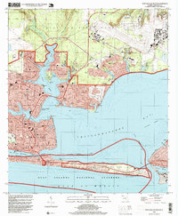
1994 Map of Fort Walton Beach
USGS Topo · Published 1999About this map
Fort Walton Beach and its surrounding communities are defined by the complex intersection of military installation and coastal development along the Florida Panhandle. The presence of Eglin Air Force Base dominates the northern and eastern portions of the map, with specialized facilities like Camp Pinchot and Eglin Village integrated into the landscape. The urban core of the city is densely plotted, showing civic infrastructure such as the Library, City Hall, and Jet Stadium. To the south, the protection of the Gulf Islands National Seashore on Santa Rosa Island preserves a narrow strip of sand dunes against the Gulf of Mexico, separated from the mainland by the Santa Rosa Sound. Key navigational features like the Intra-Coastal Waterway and the East Pass near Destin highlight the region's reliance on maritime access between Choctawhatchee Bay and the open gulf.
Find a feature on this map
58 named features on this map. Tap any name to fly to it.
Don’t see what you’re looking for? This feature index may not catch every label — zoom into the map to look around manually.
Map Details
Editions of this 1994 Fort Walton Beach Map
This is the sole edition of this map. No revisions or reprints were ever made.
Other maps of this area

1934 · Holt
USGS Topo · 1:48,000

1934 · Niceville
USGS Topo · 1:48,000

1935 · Villa Tasso
USGS Topo · 1:48,000

1936 · Niceville
USGS Topo · 1:62,500

1937 · Holt
USGS Topo · 1:62,500

1938 · Mary Esther
USGS Topo · 1:62,500

1938 · Villa Tasso
USGS Topo · 1:62,500

1956 · Niceville
USGS Topo · 1:62,500

1956 · Fort Walton Beach
USGS Topo · 1:62,500

1956 · Holt
USGS Topo · 1:62,500